Tag Archives: Walk Difficulty: Easy

Coosawhatchie HP & WMA (Frosted Elfin – Yemassee, SC)

The Carolina Butterfly Society Midlands Chapter will hold a butterfly walk on Sunday, March 16, 2025, at the 10,879-acre Coosawhatchie Heritage Preserve and Wildlife Management Area.Ā We will look for lupine and Baptisia tinctoria (horsefly weed) and a new population of Frosted Elfin, as well as other early-season butterflies. The walking is mostly on level ground and easy.

Meet at the Pocotaligo Road kiosk that is located about a quarter mile into the property. The property entrance on Pocotaligo Road is located at GPS coordinates 32.6916, -80.9193. Directions from I-95, take SC-68 West in Yemassee, exit#38. Turn onto Simmons Road and follow it to Pocotaligo Road.

No restrooms are available on the property. Refer to the SCDNR website link below for additional information and a map of the property. Either register on the CBS websiteĀ (using the ā€œRegisterā€ link above) or RSVP to our leader, Tom Austin, at the email address below if you plan to participate. Please bring water, lunch, binoculars, cameras and field guides. Sunscreen, bug spray, long pants and close-toed shoes are highly recommended.

Wateree River HP & WMA (Eastover, near Columbia, SC)

DATE CHANGE – Originally Saturday, March 8, 2025

The Carolina Butterfly Society Midlands Chapter will hold a butterfly walk on Saturday, March 1, 2025, at the 3,674-acre Wateree River Heritage Preserve and Wildlife Management Area. We will be looking for early-season butterflies, as well as a possible over-wintering Mourning Cloak or Southern Dogface. We will drive to various areas, walk some of the trails and quite possibly ā€œbushwhackā€ through fields. Some areas may be a little overgrown, but the walking is mostly on level ground and easy.

Meet at the first kiosk that is located on the right, about 0.45 miles along Goodwill Road after entering the property. GPS coordinates for the kiosk are 33.9495, -80.6530. The HP / WMA entrance is located at 15001 Goodwill Road, Eastover, SC 29044 (GPS coordinates 33.9435, -80.6555) on the north side of Garners Ferry Road, US Highway 378, just across from Goodwill Baptist Church.

No restrooms are available on the property. Dave and Marty Kastner will lead. Either register on the CBS website (using the ā€œRegisterā€ link above) or RSVP to Marty at the email address below if you plan to participate. Please bring water, lunch, binoculars, cameras and field guides. Sunscreen, bug spray,Ā long pantsĀ andĀ close-toed shoesĀ areĀ highly recommended.

See the website link below for hiking trails and other information about the Wateree River Heritage Preserve and Wildlife Management Area.

Webb Wildlife Center WMA (Hampton Co., SC)

The Webb Wildlife Center, owned and operated by the South Carolina Department of Natural Resources, is a management and research facility designed to demonstrate multiple-use wildlife and timber management. Meet in front of the WMA offices/visitor center. The restrooms are inside the visitor center which is closed on weekends.

Directions: From Columbia take Highway 321 South to Garnett. In Garnett, the road will fork, stay right on Hwy 119, turn right onto Augusta Stagecoach Road (S-20) (Across from Garnett Post Office), cross railroad tracks, go approximately 2.6 miles to James W. Webb Wildlife Management Area Entrance on the left and follow it (1.5 miles) to the office. GPS coordinates are 32.59086, -81.31240

Alison Smith will lead. Contact her at [email protected] if you plan on participating.

Tillman Sand Ridge HP & WMA (Jasper Co., SC)

Tillman Sand Ridge Heritage Preserve and Wildlife Management Area is a preserve of about 2 square miles in the Outer Coastal Plain of western Jasper County, adjacent to the Savannah River. It was established to protect one of the northernmost populations of Florida gopher tortoises, eastern diamondback rattlesnakes, and many rare plant species. The preserve has examples of two important ecosystems, longleaf pine savanna and Outer Coastal Plain floodplain forest.

Directions: From the little village of Tillman (at the junction of Highways 336 and 321) turn onto Sand Hills Road. Continue on Sand Hills Road to the kiosk at a small parking area just off the left side of the road. GPS coordinates for the kiosk are 32.499295, -81.1999621.

There are no organized hunts at this location, but all participants should wear orange for the walk. Do not walk on any of the gopher tortoise mounds. There are no facilities at this site.

For those who need to stay overnight, hotels are available in Hardeeville.

Alison Smith will lead. Contact her at [email protected] if you plan on participating.

CANCELLED – Pre-Symposium Walk – Mason Farm Biological Reserve (Chapel Hill, NC)

CANCELLED – Due to damage, flooding and road closures from hurricane Helene, the CBS Board has decided to cancel the October 5 symposium and this walk that was scheduled for Friday, October 4.

LOCATION CHANGE (due to hunting at previous venue)

This is a pre-symposium butterfly walk butĀ anyone is welcome whether they plan on attending the symposium or not.

We will meet at the parking lot at Mason Farm Biological Reserve trailhead. There is no street address, but the GPS coordinates are 35.89233, -79.01647. The walking loop is about 2 miles or so and is flat. The trail winds through several habitats including hardwood forest, mixed pine forest, open fields, and has a nice boardwalk section through a wetland. Approximately 60+ species of butterflies have been tallied here over the years and seasons. Of course, we will not have that diversity in October, but itā€™s still a nice walk. Jeff Pippen and Dave and Marty Kastner will lead.

No restrooms are available on the property. Please bring water, snacks (or a late lunch), binoculars, cameras and field guides. Sunscreen, bug spray, long pantsĀ andĀ close-toed shoesĀ areĀ highlyĀ recommended.

Directions – From the north, drive to Finley Golf Course Road in Chapel Hill. Drive around the Finley Golf Club clubhouse and parking lot and past the driving range. Directly after the driving range at the power lines, take the right fork onto Mason Farm Acc Road (which passes under the power lines). After about 0.38 miles, turn to the right on the gravel access road to the creek, then drive over the concrete ford (which always has at least some water flowing over it, but should be passable). The trailhead parking lot is just to the south of the creek.

Please use the symposium registration form if you are attending the symposium and plan to participate. If you are NOT attending the symposium, you can register for this walk online at the CBS website or RSVP to Marty Kastner at the email address below.

Mount Mitchell SP, Commissary Road Trail (Burnsville, NC)

This will be the first field trip for the newly created Western NC Chapter!

Attendees will meet at 11:00 am at 96 Holland Street, Asheville, 28801 (GPS coordinates 35.60645, -82.55455) and carpool to the Tourist Information Center at Mount Mitchell State Park (MOMI). The drive from Asheville to MOMI takes about an hour, mostly on the Blue Ridge Parkway. Carpooling is important since parking will be tight at this building during what is expected to be peak leaf season.

Our target species is the Green Comma. This is the best time and only reliable place to find them in North Carolina. We will explore along the Commissary Road Trail, which is an easy, graveled trail that starts near the back of the Tourist Information Center. Bathrooms are available at this building.

If you’re traveling from out of town and plan on staying overnight, make your hotel reservations early, again due to the probable demand during peak leaf season. If needed, the rain date will be Sunday, September 29.

Our trip leader is Heather Rayburn, who can be reached at the email address listed below. Please either contact Heather or register on the CBS website if you plan on attending.

Southern 8ths Farm (Chesterfield, SC)

This is a full CBS field trip that will be to a new location for us in northeast South Carolina, almost to the state line with North Carolina. We will meet our host, Brad Turley, at the GPS coordinates listed below at 9:00 AM.

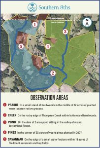
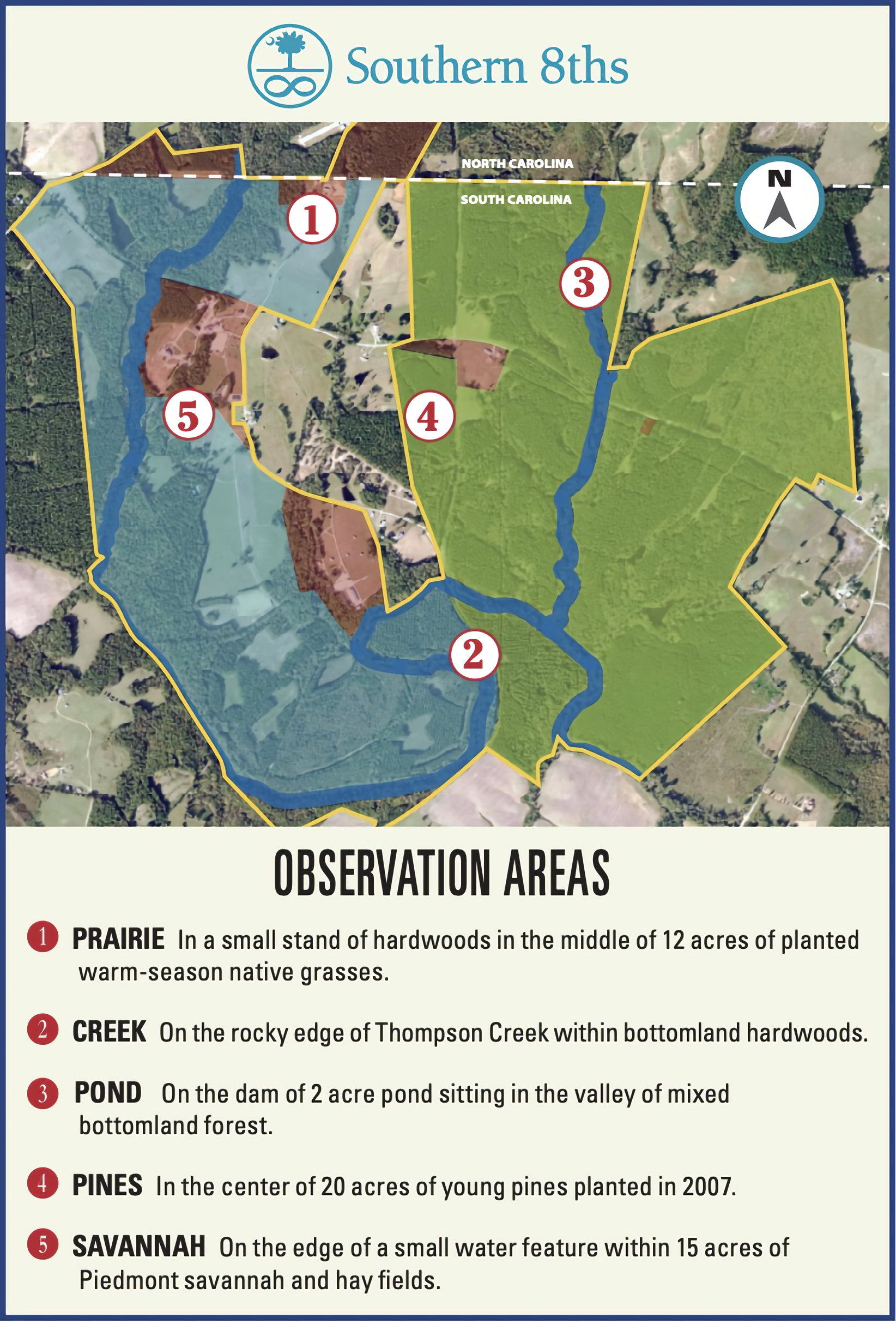
Southern 8ths is located in an area of convergence, where the Piedmont & Coastal Plain meet along the state line of North and South Carolina. This land is rich in American and natural history and has a history of horses being present since the late 18th century. The geophysical nature of these 1,400 acres of preserved land has encouraged the growth of rolling pastures and fields, diverse upland and bottom land hardwood forests and planted pine stands. The waters of Thompson Creek and its tributaries drop over shale bases to join the Great Pee Dee River and flow to the Atlantic. This land is home to reclaimed grass prairies full of insects and dappled sunlit woodland trails, offering respite to birds, mammals, reptiles, amphibians, and humans. This ā€œcorridor of greenā€ is a work-in-progress, and it is teaching us about its future role in the survival of humankind and animal-kind. Per Tom Austin, the organizer for this trip, and referring to the map below, the proposed “schedule” is as follows:

9:00 – 9:30 AM
Meet at the Learning Center (GPS coordinates 34.79584, -80.15313), located behind the horse barns at 305 Lucious Davis Road for welcome, introductions, to use restrooms and fill up on water. On the map, this is the reddish area between Points 5 and 2. The driveway entrance to the property is located at GPS Coordinates 34.79965, -80.15423 on the south side of Lucious Davis Road.

9:30 – 10:30 AM
Head out via carpool to the Fireworks East/West and Red Banks Prairies, our two most diverse Southeastern grasslands. They total over 15 acres and include a pond and some woods and should be loaded with butterflies. Folks will have plenty to explore there, and some shade if they need it. This is the cleared area around Point 1 on the map.

10:30 to 12 noon
Walk along a wooded trail through mixed upland hardwoods and pines, cross a small creek, and head to Frances’ Field, a smaller prairie with thinner, drier soils and lots of natives, and then to BJ’s Pond, a mature wooded pond with some sunnier openings. The walk is west of Point 1 to the small prairie, pond and back.

12:30 – 1:30 PM
Carpool back to cool off at the Learning Center for a brown-bag lunch-and-learn orientation / PowerPoint about Carolina Wildlands.

1:30 – 3:00 PM
If people are up for it, we could walk from the Learning Center on trails in the shadier alluvial forest along Thompson Creek, passing several managed grasslands, before heading home. This is the floodplain area west of Point 2 on the map.

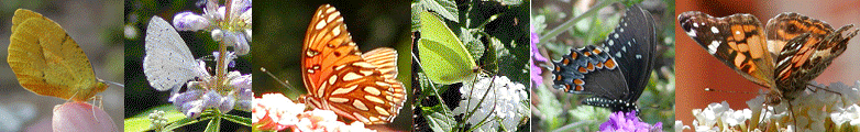
Noted nectar plants: Mountain Mint, Wild Bergamot, Roughleaf Sunflower, Blazing Star, Common Milkweed, Butterfly Weed, Brazilian Vervain, Ironweeds, Maryland Golden Aster, Cottony Goldenaster, Common Yellow Thistle, Bull Thistle, Late Boneset, Blue Lobelia, Black Eyed Susan, and 7 species of Goldenrod. (I think we’ll be transitioning between the bloom times of most of these.)

I think this walk is going to be nectar driven from what I recall about the property from late fall and the season. Sounds like we’ll be looking for Vervains, Mountain-Mint, and any Sunflowers and Blazing-stars coming into bloom. Should be Ironweed and Lobelia in the wetter areas too. Hopefully there’s some Prunella around too.

It is recommended that you bring additional snacks, food, and beverages as during the walks we will be away from public facilities. Wearing sturdy walking or hiking shoes is recommended along with long sleeves and pants as we may go off trail in some locations to look for as many butterfly species as possible. It is also recommended you use a good bug spray, wear sunscreen, and carry water with you. Be sure to bring those items you may need (camera, binoculars, field guides, etc.).

The closest cities to Southern 8ths Farm that have a selection of accommodations are 1) Cheraw, SC, about a 30 minute drive and 2) Rockingham, NC, about a 40 minute drive.

Tom Austin, who can be reached at the email address listed below, made the arrangements for this field trip. Please either contact Tom or register on the CBS website if you plan on attending.

Reynolda Gardens 2024 (Winston-Salem, NC)

On Saturday, October 19, 2024, the Triad Chapter of CBS (Carolina Butterfly Society) will hold a butterfly walk at the FORMAL GARDENSĀ area of Reynolda Gardens.

After the CBS walk through the formal gardens, attendees are welcome to stay a little longer and visit other areas of the 134-acre grounds. These other areas include two miles of scenic walking trails, wetlands, paved pathways, thick woodlands, an expansive meadow for visitors to explore and enjoy and a waterfall, located along the Reynolda Village trail. Refer to the website below for a map and additional information.

Meet at the garden entrance greenhouse at 100 Reynolda Village, Winston-Salem, North Carolina 27106 (or for those who prefer GPS coordinates, 36.12564, -80.28474). Please RSVP to Barbara Cullen at the email address below if you plan to participate.

Triad Chapter Coordinator’s Home Pollinator Garden (Forsyth County)

The Triad Chapter of CBS will hold a butterfly walk on Saturday, September 14 to the Triad Chapter coordinator’s home pollinator garden in Winston-Salem, NC. Please bring water, and, if you have them, a butterfly field guide, binoculars and a camera.

If you want to join in on this butterfly walk, you must register, either online at the CBS website or RSVP to Bernyce Pritchard, the walk organizer, at the email address below.


Marie Poteatā€™s Property (Jamestown, NC)

The Triad Chapter of CBS will hold a butterfly walk on Saturday, August 17 to Marie Poteatā€™s property in Jamestown, NC. Of all the triad butterfly reports this year, Maries by far have had the most butterflies. In large part, this is because Marie has spent years reintroducing caterpillar host plants and butterfly nectar plants on what was once her familyā€™s 70-acre+ working farm. For those interested in Monarch butterflies, she has more than 25 species of the milkweed host plants. This hard work has paid off. She probably has more butterfly species visiting and breeding on her property than any other location in Guilford County.

Note that there areĀ no rest rooms available; be sure to make a ā€œpit stopā€ in town before you continue to the Poteat property. In addition, you will have to bring everything you need including water, a snack, a folding chair, a butterfly field guide, and, if you have them, binoculars and a camera.

Marie isĀ limiting the number of participants to about 10 ā€“ 12 people. If you want to join in on this butterfly walk, youĀ MUST registerĀ by contacting Marie at the email address below.

Summary: Butterfly walk, 8-17-24, Marie Poteat Property, 1111 Bales Chapel, Jamestown, NC beginning at 9:30 a.m. Limited to 10-12 participants. YOU MUST REGISTER IN ADVANCE IN ORDER TO PARTICIPATE!